

Signals: S5 Acute Climate Hazard · S6 Chronic Climate Stress · S10 Migration & Demographic Shift
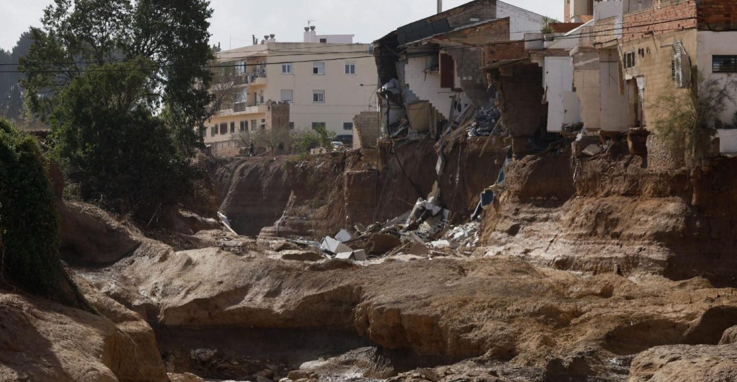
Photo credit: Kai Försterling for the European Pressphoto Agency (EPA)
On October 29, 2024, the municipality of Chiva received 491.2 mm in 8 hours, including 343 mm in 4 hours, and more than 300 mm fell over the day across the Utiel-Chiva corridor.
That is roughly a year of precipitation, delivered in a single working day.
Valencia was not on anyone’s list of high-risk real estate markets. It had a flood map, a drainage system, and a modern meteorological service that issued its maximum red alert that morning.
The Moment
A DANA is a cut-off low, a pocket of cold air that separates from the jet stream and stalls over warm Mediterranean water. Spain gets them most autumns. This one sat over the Valencian interior and did not move.
The rainfall totals were not marginal. At Chiva, 343 millimeters fell in four hours, and more than 300 millimeters fell across the Utiel-Chiva corridor over the full day. Some areas received more than a full year’s worth of rain in eight hours.
The Spanish meteorological agency raised its red alert for the Valencia interior at 7:36 that morning. It extended it across the whole province by 9:41. The regional emergency alert reached mobile phones at 8:11 that evening. The water arrived in between. Spain still politically contests that sequence.
What matters for an investor is narrower and more transferable than assigning blame. The hazard was forecast. The warning existed. And the built environment could not absorb the gap between the two because it was built on the assumption that the gap would never be tested.
237 people died. Total economic damage is commonly cited at around €16.5 billion. Insured losses are estimated at approximately €4.8 billion, and Spain’s Insurance Compensation Consortium had paid more than €4 billion across 250,663 claims as of November 24, 2025.
The Story
The number that reframes this event is not the damage figure. It is the denominator.
The Valencian Institute of Economic Research put the total value of private and public assets located in the flooded municipalities at €85.9 billion. It estimated that at least 20% of it was destroyed.
A regional flood in a mid-sized European metropolitan area sat atop an asset base approaching €90 billion. The loss was large because the exposure was large, and the exposure was large because nobody had priced the location as exposed.
This pattern makes the phrase “safe market” dangerous. Valencia was safe in the sense that mattered least. It had not recently flooded. It was not safe in the sense that mattered most, in that a great deal of value had accumulated in places water had historically traveled.
Much of the affected development sits on or near ramblas, the dry riverbeds that carry water only during extreme rainfall. For most of a human lifetime, a rambla looks like flat, buildable, well-drained land. It is neither flat by accident nor dry by nature. It is a channel that is empty most of the time.
A flood map drawn from the recent record will show a rambla as low risk because the recent record is a period when it did not rain that hard. The map is not wrong about the past. It is being asked a question about the future that it was never built to answer.
That distinction applies to markets within and beyond Spain.
Valencia had solved this problem once already. After a catastrophic flood in 1957, the city diverted the Turia River into a new channel south of the urban core and turned the old riverbed into a park. It was one of the most ambitious pieces of urban flood engineering in twentieth-century Europe, and it worked.
What it did not do was protect the municipalities inland of the city, where the growth of the following decades actually went. The engineering team defended the flooded area. The development moved to areas that had not yet flooded.
That is a pattern, not a coincidence. Protective infrastructure raises the perceived safety of an entire region, not only the parcels it defends, and the development that follows tends to spread past the edge of the protection. The map showed a protected city. The buildable land sat outside the protection.
Spain covers extraordinary risks through the Consorcio de Compensación de Seguros, a national pool funded by a surcharge on ordinary policies. Flood coverage is therefore close to universal rather than optional, as it is in the US, which is why the estimated insured cost runs to about €4.8 billion in a country where nobody buys standalone flood insurance.
In the United States, flood is severable, federally underwritten, and mostly unpurchased outside mandatory-purchase zones. Same hazard, entirely different distribution of who absorbs the loss. A comparable event in the US would result in a smaller insured loss and a much larger uninsured loss.
Structural Forces
Three forces determine whether a market’s risk map still accurately describes it.
The first is that the underlying probability has moved. World Weather Attribution’s analysis of this event found that one-day rainfall of this intensity is now roughly twice as likely and about 12% more intense than it would have been without climate warming.
If an event has become twice as likely, then a drainage system engineered against a hundred-year rainfall is now defending against something closer to a fifty-year rainfall. The concrete did not change. The number the concrete was poured against did.
A separate analysis from the Barcelona Supercomputing Center found that a warming North Atlantic contributed to the storm’s intensity by loading the atmosphere with additional moisture, adding about 15% to the episode’s intensity. Warm water is fuel. The Mediterranean has been getting warmer.
The second force is that the map and the hydrology have separated. A flood map is a snapshot of modeled expectation at a moment in time, produced on a revision cycle measured in years or decades. The hydrology it describes is now outpacing the revision cycle.
Any investor holding assets in a market whose flood maps have not been recently revised is holding assets priced against a document that is aging out. That is not a Spanish problem. That is why FEMA’s mapping backlog matters in the United States, and why First Street’s modeling identifies 17.7 million properties at 1% annual flood risk against 7.9 million inside FEMA’s designated zones.
The third force is slower and demographic. Places that flood repeatedly eventually lose the population that makes their real estate valuable. That process does not begin with the flood. It begins with the second flood, or with the moment insurance becomes unavailable, whichever arrives first.
Valencia is a large, economically diverse metropolitan region, and it will absorb this. Smaller places do not always do so. The mechanism to watch is whether a market retains the households and employers that make a rent roll durable, because population is upstream of every leasing assumption in a pro forma.
Next Chapter
The practical conclusion is that a “safe market” is not a category. It is a claim about a specific hazard, at a specific parcel, against a specific and dated model.
So the question to ask about any market is not whether it is safe. It is three narrower questions that can actually be answered.
What is this parcel’s hazard exposure according to a model built this decade, rather than according to the regulatory map, which may be considerably older?
When were the governing flood maps last revised, and what rainfall record were they built from? A map produced before the last decade of observations is describing a different climate.
What is the accumulated asset value in the surrounding hazard zone? This is the Valencia lesson. Your loss depends on your exposure, but your market’s liquidity depends on everyone’s.
Often, the worst-hit municipalities sit inland, and the water that destroys the value comes from the sky and down a dry riverbed or mountainside, not always from the sea or storm surge pushing inland up a river.
The transferable point is that the most expensive climate exposures are the ones a market has ignored as exposures. Coastal risk is priced, sometimes badly, but it is priced. Inland flash-flood risk in a Mediterranean metro, a Southern Appalachian mountain town, or a Midwest suburb often isn't priced at all because the last event predates everyone currently underwriting.
Brief 10 takes this into the credit market and looks at how lenders are rewriting mortgage criteria for exactly this reason. Brief 11 puts a deal-level number on the same failure in western North Carolina.
As always, KNOW YOUR SIGNALS and BE CLIMATE READY!
Jamie
Go deeper
This is a Story & Future Thinking brief, so there is no companion workbook. The blank master CRDF Signal Tracker and Deal Stress Test are free and available at climatereadyre.com/tools.
Related briefs
Same signal (S5 Acute Climate Hazard):
Brief 3 · Hoboken Property Values: The Impact of $230M Post-Sandy Flood Infrastructure
Brief 6 · The 30-Year Mortgage and Climate Risk: What the LA Fires Exposed About Loan Duration
Brief 27 · Flood Zoning and Building Permits in Valencia: A EUR 4B Payout - coming soon
Next in sequence:
Brief 10 · Bank Lending Criteria and Climate Risk on Property: The New Overlays - coming soon
Sources
Every figure above, with the date the data covers, the date it was published, and the date I verified it.
Rainfall at Chiva — 491.2 mm in 8 hours, 343 mm in 4 hours, and 160 mm in 1 hour at the Chiva weather station.
European Severe Storms Laboratory — Meteorological analysis of the extreme flash flood situation in the Valencia region; WMO — Devastating rainfall hits Spain in yet another flood-related disaster (Oct 31, 2024), carrying AEMET’s areal totals · Data as of Oct 29, 2024 · Published Nov 5, 2024 · Accessed Aug 2026
ESSL carries the sub-daily station values verbatim. The “more than 300 mm” full-day areal totals and the “a year’s rainfall in eight hours” comparison are AEMET statements carried by the WMO news item.
Death toll — 237 deaths across Spain. 229 were in the Valencia region, 7 in Castilla-La Mancha and 1 in Andalusia.
Plataforma Media — State funeral for 237 victims in Valencia, one year after tragedy · Data as of Oct 2025 · Published Oct 29, 2025 · Accessed Aug 2026
237 is the consolidated national toll used at the October 2025 state funeral. ECMWF Newsletter 183 states “at least 232,” an April 2025 vintage, and cannot carry this figure. The 1957 Turia flood that led to the river’s diversion killed 81 (ESSL, Historical deadly flash floods in Spain, Oct 31, 2024).
Total economic damage — around €16.5 billion.
ECMWF — Extreme precipitation in Spain’s Valencia region (Newsletter 183) · Data as of Oct 29, 2024 · Published Apr 2025 · Accessed Aug 2026
ECMWF carries the €16.5 billion figure verbatim. Damage estimates vary widely by methodology and vintage; wider ranges circulate, but no single named source carries them, so none is stated here.
Insured losses and Consorcio payouts — estimated final insured cost of approximately €4.8 billion; the Consorcio de Compensación de Seguros had paid more than €4 billion across 250,663 claims as of November 24, 2025.
Consorseguros Digital — The 2024 Valencia Floods · Data as of Nov 24, 2025 · Published autumn 2025 (issue 23) · Accessed Aug 2026
Scope: CCS-insured cost only, never total economic damage. These are the source’s own current figures — about €4.8 billion estimated final insured cost, with more than €4 billion paid across 250,663 claims as of November 24, 2025.
Asset value in the flooded municipalities — €85.9 billion of private and public assets located in the affected municipalities, with at least 20% estimated destroyed.
Ivie, Valencian Institute of Economic Research — La DANA puede haber destruido al menos el 20% de los 85.900 millones de euros de activos privados y públicos localizados en los municipios inundados · Data as of Jan 2025 · Published Jan 17, 2025 · Accessed Aug 2026
Attribution — one-day rainfall of this intensity is roughly twice as likely and about 12% more intense in the current climate.
World Weather Attribution — Extreme downpours increasing in southern Spain as fossil fuel emissions heat the climate · Data as of Oct 2024 · Published Nov 4, 2024 · Accessed Aug 2026
The doubling attaches to regional one-day rainfall in an observations-only trend analysis, not to the eight-hour accumulation at Chiva.
Ocean warming contribution — a warming North Atlantic contributed to the storm’s intensity, adding about 15% to the episode’s intensity (Saurral and colleagues, Weather and Climate Extremes, Mar 16, 2026).
PreventionWeb — BSC study reveals warming North Atlantic contributed to intensifying Valencia DANA storm · Data as of Oct 2024 · Published Mar 16, 2026 · Accessed Aug 2026
Warning timeline — AEMET raised its red warning for the Valencia interior at 7:36 on the morning of October 29, 2024, and extended it to the whole province at 9:41; the Generalitat’s ES-Alert mobile warning went out at 20:11.
Maldita.es — Cronología de la DANA: avisos de la AEMET y alertas de Protección Civil, 29 de octubre de 2024 · Data as of Oct 29, 2024 · Published Oct 30, 2024 · Accessed Aug 2026
The timeline is widely reported and remains politically contested in Spain. The timeline comes from Maldita.es’s reconstruction of AEMET’s published warnings and the Generalitat’s alert. The sequence is stated; no causal claim is made about specific deaths.
US flood exposure beyond the federal maps — 17.7 million properties at 1% annual flood risk versus 7.9 million in FEMA Special Flood Hazard Areas, roughly 2.2x. MSCI acquired First Street in August 2026; a commercial index provider rather than an independent foundation now owns the model.
First Street — High Water, High Stakes: FEMA · Data as of Jul 2025 · Published Jul 2025 · Accessed Aug 2026
Commentary and analysis only. Not investment, financial, legal, tax, or professional advice. CRDF tools are illustrative; examples are composites drawn from public data. Do your own due diligence and consult qualified professionals.
I run this analysis on specific deals. If you are underwriting an asset in a market everyone calls safe and want the hazard and insurance assumptions pressure-tested before you sign, book 20 minutes.
Jamie Wolf, MBA — Founder & Publisher, Climate-Ready Real Estate Investing, © 2026, CR REI Holdings LLC